
1. Киришүү
The SMAJAYU SMA26 Pro RTK GNSS Surveying Equipment is a high-precision, full-constellation 4G RTK GNSS receiver system designed for various surveying applications including land surveying, engineering, and drone base station operations. This system includes both a Rover and a Base RTK receiver, along with an Android handheld device featuring pre-installed surveying software. It offers wide protocol compatibility, supporting PPP, PPK, and RTK technologies for versatile and accurate performance.

Figure 1: SMAJAYU SMA26 Pro RTK GNSS Surveying Equipment (Rover and Base)
2. Кутуда эмне бар
The SMA26 Pro RTK GNSS Surveying Equipment package includes the following components:
- 2 x GNSS receivers (one Rover, one Base)
- 1 x Handheld controller (Android 11, 5.45-inch HD screen)
- 1 x Handheld bracket
- 1 x Handheld Charger
- 2 х Power адаптерлери
- 2 x Terminal Antennas
- 1 x рулетка
- 1 x узартуу таякчасы
- 1 x Disc
- 1 x User Manual

Figure 2: Package Contents for SMA26 Pro RTK Rover and Base
For a visual guide on unboxing the product, please refer to the video below:
Video 1: Product Unboxing Guide
3. Продукт бүтүп калдыview
3.1 Негизги өзгөчөлүктөрү
- High Capability & Compatibility: Full-constellation 4G RTK GNSS receiver with wide protocol compatibility (CSS Lora, Transparent, TT450S, Trimtalk, TRMMARK3, SOUTH, SATEL). Supports PPP, PPK, and RTK technologies.
- High-Precision GNSS System: RTK horizontal accuracy of ±8mm and tilt measurement accuracy of 2.5cm.
- Эңкейүү компенсациясы: Tilt accuracy up to 2.5 cm (at tilt angles ≤30°), supporting up to 60° for precise measurements in challenging areas without calibration.
- All-in-One Integration: Built-in Bluetooth, UHF radio, 4G, Wi-Fi, IMU, antenna, and 32GB storage. Easy switching between base station and rover modes.
- Smart Handheld Collector: Android 11 unit with a 5.45-inch HD screen, dual SIM, 9000mAh battery, NFC, IP68 protection, dual-frequency RTK support, and a 13-megapixel camera.
- Күчтүү жана ишенимдүү: IP67 waterproof and dustproof rating, 2-meter drop resistance. Operates in temperatures from -45℃ to +75℃. 10000mAh battery provides up to 20 hours of continuous operation.

Figure 3: SMA26 Pro vs. SMA26 Model Comparison

Figure 4: High-Precision Tilt Surveying Capabilities

Figure 5: FP88 Data Controller Features
3.2 Компоненттер жана интерфейстер
The SMA26 Pro GNSS receiver features a user-friendly design with clearly marked buttons and indicator lights. The interfaces are designed for robust field use.
- Still Recording Button: Press and hold for 4 seconds to turn on or off the still recording mode.
- Кубат баскычы: Press and hold for 2 seconds to turn on or off (Bluetooth will also be turned on).
- Recorder Light: Red, flashes when static recording mode is on, otherwise off.
- Күч жарыгы: Three-color light (charging, fully charged, working, low battery).
- Satellite Light: Red, RTK Fix is flashing.
- Differential Light: Red, flashes once per second when the radio or 4G module receives or sends data, and does not flash when there is no differential data.
- Туруктуу жип: Five-eighth inch thread for mounting.
- Anti-dust Plugs: Internal connectors are divided into base station and rover accessories.
- UHF Radio Antenna Interface: For external UHF antenna connection.
- Type-C Connector and SIM Slot: For data transfer and 4G connectivity.

Figure 6: SMA26 Pro GNSS Receiver Front Panel and Interfaces
Толук маалымат алуу үчүнview of the SMA26 Pro's features, watch the video below:
Video 2: SMA26 Pro Features Overview
4. Орнотуу
Setting up your SMA26 Pro RTK system involves preparing both the Rover and Base units. Ensure all components are present and charged before deployment.
4.1 Rover орнотуу
- Attach the handheld bracket to the extension rod.
- Secure the handheld controller into the bracket.
- Mount the SMA26 Pro Rover GNSS receiver onto the top of the extension rod.
- Connect the terminal antenna to the Rover unit.
- Ensure the Rover unit and handheld controller are fully charged.
4.2 Базалык станцияны орнотуу
- Set up a stable tripod in a clear location.
- Mount the SMA26 Pro Base GNSS receiver onto the tripod using the provided disc and extension rod (if needed).
- Connect the terminal antenna to the Base unit.
- Ensure the Base unit is fully charged.
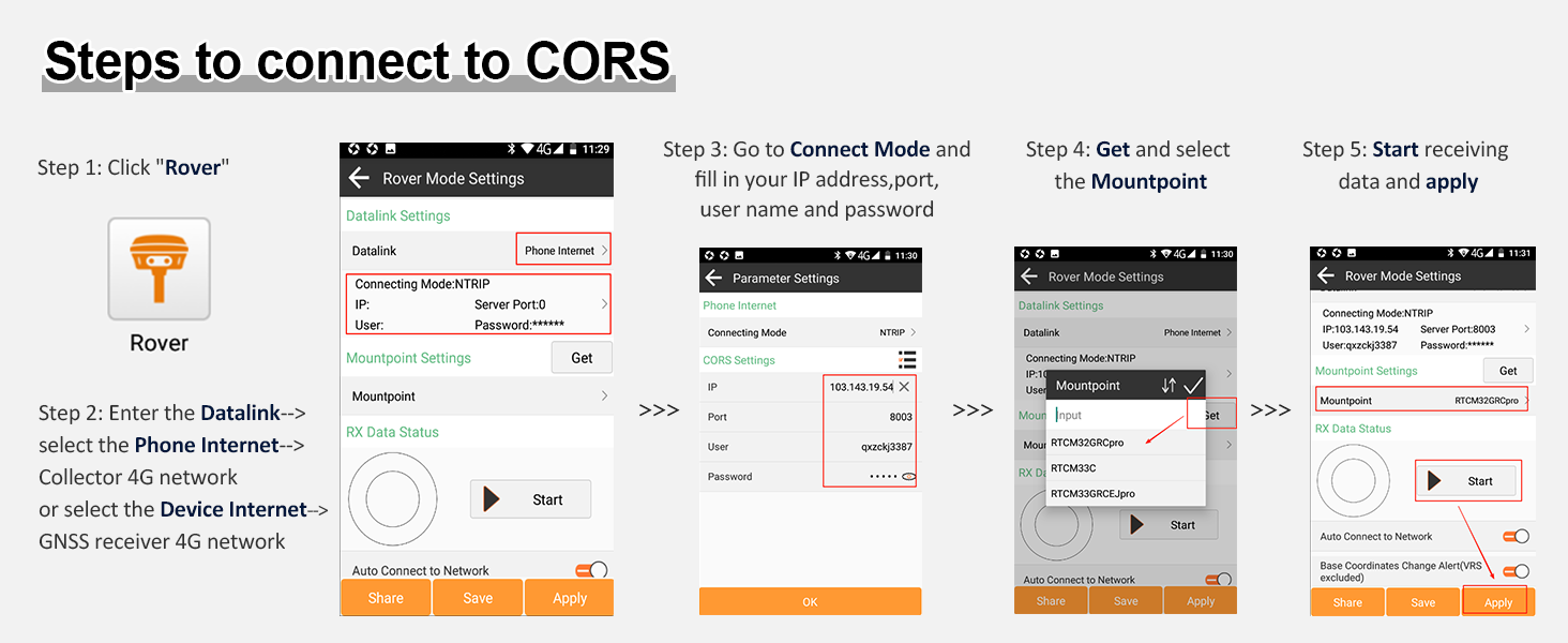
Figure 7: Contents of Rover and Base Boxes
5. Иштөө нускамалары
The SMA26 Pro RTK system supports various surveying modes and offers convenient measurement capabilities.
5.1 Surveying Modes
The SMA26 Pro RTK supports multiple surveying modes to suit different project requirements:
- Static Surveying (Base): Performs static data collection for high-precision positioning. Ideal for control point establishment and long-duration surveys, offering 2.5mm high accuracy.
- RTK Surveying (Rover + Base): Real-time sub-centimeter-level accuracy, suitable for dynamic surveying tasks.
- CORS тармактык интеграциясы: Connects to Continuously Operating Reference Stations (CORS) networks. Cost-effective and efficient for large areas, eliminating the need for a physical base station.
- SMA26 Rover + Base PPK: Base station collects static data while SMA26 rover enables Post-Processed Kinematic (PPK). Combines static and PPK for maximum precision, ideal for areas with poor RTK signal.
- SMA26 Rover PPP: Utilizes Precise Point Positioning (PPP) with Galileo HAS corrections, achieving centimeter accuracy without the need for a base station.

Figure 8: SMA26 Pro RTK Surveying Modes
5.2 Connecting to CORS
To connect your SMA26 Pro Rover to a CORS network, follow these steps:
- Click "Rover" in the surveying software.
- Enter the Datalink settings and select "Phone Internet" (for Collector 4G network) or "Device Internet" (for GNSS receiver 4G network).
- Go to "Connect Mode" and fill in your IP address, port, username, and password.
- Get and select the Mountpoint.
- Start receiving data and apply settings.

Figure 9: Steps to Connect to CORS
5.3 Measurement Operations
The SMA26 Pro system offers various measurement functions and data handling capabilities.
- Tilt Measurement (IMU): The integrated IMU allows for tilt measurement up to 60 degrees, providing accurate data even in obstructed areas.
- Polygon Surveying: Easily define and measure polygonal areas.
- Көлөмдү эсептөө: Perform volume calculations directly from collected data.
- Data Import/Export: Seamlessly import and export data for further processing.
- Drone Connectivity: The SMA26 Pro can connect with drones for integrated surveying workflows.
Refer to the following videos for specific operation guides:
Video 3: SMA26 Pro RTK GNSS Tilt Measurement (IMU)
Video 4: SMA26 Pro RTK GNSS Polygon Surveying
Video 5: SMA26 Pro RTK GNSS Volume Calculation
Video 6: Data Import Operation
Video 7: Data Export Operation
Video 8: Steps to Output Debug File
Video 9: SMA26 Plus/Pro and SMA28H Connect with Drones!
Video 10: SMA26 PRO/PLUS RTK GNSS Point Calibration
6. Техникалык тейлөө
Proper maintenance ensures the longevity and accuracy of your SMA26 Pro RTK GNSS Surveying Equipment.
- Тазалоо: Regularly clean the GNSS receivers and handheld controller with a soft, dry cloth. Avoid abrasive cleaners or solvents.
- Сактагыч: Store the equipment in its original transport cases in a cool, dry place when not in use.
- Батареяга кам көрүү: Fully charge batteries before long-term storage and recharge every 3-6 months to maintain battery health.
- Программалык камсыздоонун жаңыртуулары: Өндүрүүчүнү текшериңиз webоптималдуу иштешин жана жаңы функцияларга жетүүнү камсыз кылуу үчүн прошивка жаңыртуулары үчүн сайт.
- Текшерүү: Before each use, inspect all cables, connectors, and antennas for any signs of wear or damage.
7. Кыйынчылыктарды
If you encounter issues with your SMA26 Pro RTK system, consider the following common troubleshooting steps:
- Кубат жок: Ensure batteries are fully charged and properly inserted. Check power cables and adapters for damage.
- Poor Signal/Accuracy: Ensure clear line of sight to the sky for GNSS receivers. Check antenna connections. Verify CORS network settings (IP, port, login). Ensure IMU is initialized for tilt measurements.
- Туташуу маселелери: Check Bluetooth, Wi-Fi, or 4G connections. Ensure devices are paired correctly. Restart both the receiver and handheld controller.
- Программалык камсыздоонун бузулушу: Restart the handheld controller and the surveying application. Ensure the software is up-to-date.
- Маалыматтарды өткөрүү көйгөйлөрү: Check USB cable connections. Ensure correct data import/export settings in the software.
If problems persist, contact SMAJAYU customer support for assistance.
8. Техникалык шарттар
| Өзгөчөлүк | Спецификация |
|---|---|
| Элемент Салмагы | 2.27 фунт |
| Продукциянын өлчөмдөрү | 16.14 x 14.76 x 12.99 дюйм |
| Элемент моделинин номери | SMA26 Pro RTK |
| Батареялар | 4 литий металл батарейкалары талап кылынат (кошулган) |
| Display Size (Handheld) | 5.45 дюйм |
| Батареянын иштөө мөөнөтү | 20 саат |
| Үн буйругу | Buttons |
| Өзгөчө өзгөчөлүк | Bluetooth |
| Байланыш технологиясы | Bluetooth, USB, Wi-Fi |
| Карта түрү | Бүткүл дүйнөлүк |
| Монтаж түрү | Колдук |
| Операция системасы | Android |
9. Кепилдик жана колдоо
The SMAJAYU SMA26 Pro RTK GNSS Surveying Equipment comes with a 1 жылдык кепилдик сатып алынган күндөн тартып.
For technical assistance, troubleshooting, or any product-related inquiries, SMAJAYU offers 24 сааттык колдоо. Please refer to the contact information provided in your Quick Start Guide or visit the official SMAJAYU webколдоо чоо-жайы үчүн сайт.