
1. Киришүү
This manual provides detailed instructions for the setup, operation, and maintenance of your SMAJAYU SMA28H Laser RTK and SMA26 Pro Base GNSS Survey System. This system is designed for high-precision surveying applications, offering advanced features such as 2cm accuracy laser measurement, dual-camera AR real-scene stakeout, and robust multi-network GNSS connectivity.
2. Пакеттин мазмуну
Төмөндө тизмеленген нерселердин баары пакетиңизге камтылганын текшериңиз. Эгерде кандайдыр бир нерселер жок болсо же бузулса, кардарларды колдоо менен байланышыңыз.

Image: SMA28H and SMA26 Pro Base package contents.

Сүрөт: деталдуу view of SMA28H and SMA26 Pro Base components.
2.1 SMA28H Rover List:
- 1x SMA28H Receiver
- 1x Колдук контроллер
- 1x Handheld Bracket
- 1x Power адаптер
- 1x заряддоо кабели
- 1x Радио антеннасы
- 1x Колдонуучунун колдонмосу
2.2 SMA26 Pro Base List:
- 1x GNSS Receiver
- 1x Power адаптер
- 1x Disc
- 1x Extension Rod
- 1x рулетка
- 1x Terminal Antenna
- 1x Колдонуучунун колдонмосу
2.3 Unboxing Videos:
Video: SMA26 Pro RTK Unboxing. This video demonstrates the unboxing process for the SMA26 Pro Base unit, showing all included components.
Video: SMA28H Unboxing. This video guides you through unboxing the SMA28H Rover, detailing each component.
3. Продукциянын өзгөчөлүктөрү
- 2cm Accuracy Laser Measurement: Non-contact point measurements up to 30m, with 3-4cm accuracy within 15m. Ideal for hard-to-reach points.
- Dual Cameras AR Real Scene Stakeout: Features dual high-definition cameras for augmented reality (AR) stakeout, displaying points directly on the live video feed for intuitive guidance.
- 120° Tilt Survey with High Accuracy: Integrated Inertial Measurement Unit (IMU) provides less than 2cm accuracy within a 60° tilt range, supporting angles up to 120°.
- Алыскы аралыктагы байланыш: Integrated UHF radio communication system with a working range of up to 15 kilometers in open environments.
- Multi-Network GNSS Connectivity: Supports PPP, PPK, RTK, and direct CORS network connections with a built-in 4G module for direct network access via SIM card.
- Туруктуу дизайн: IP67 waterproof and 1.8m drop-tested.
- Узартылган батареянын иштөө мөөнөтү: 6600 mAh battery provides up to 20 hours of rover use.
- Байланыш: Integrated 4G LTE, UHF radio, Wi-Fi, Bluetooth, and WEBUI платформасы.

Сүрөт: бүттүview of SMA28H features including battery, channels, IP rating, 4G, NFC, and WEBUI.
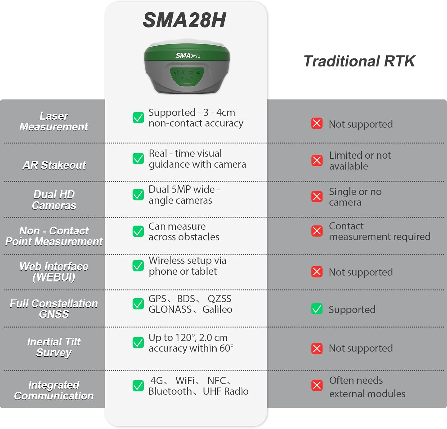
Image: Comparison table highlighting SMA28H advantages over traditional RTK systems.
4. Орнотуу
4.1 Алгачкы Ассамблея
- Attach the SMA28H Rover to the handheld bracket and secure it.
- Connect the radio antenna to the SMA28H Rover.
- For the SMA26 Pro Base, attach the terminal antenna and extension rod as needed.
- Бардык компоненттердин бекем бекитилишин текшериңиз.
4.2 Күйгүзүү жана туташуу
- Power on both the SMA28H Rover and SMA26 Pro Base units.
- On the handheld controller, navigate to the communication settings.
- Select the appropriate RTK model (SMA28H) and connect via Bluetooth.
- Ensure a fixed solution state is achieved for accurate measurements.
5. Иштөө нускамалары
5.1 Laser Measurement
The SMA28H features a visible green laser for non-contact measurements, ideal for points that are difficult to access directly.

Image: SMA28H GNSS Receiver demonstrating non-contact, high-precision laser measurement.
To perform laser measurements:
- Ensure the SMA28H is in rover mode and has a fixed solution.
- Navigate to the 'Survey' menu on the handheld controller and select 'Point Survey'.
- Click the laser mode icon, then the laser-assisted camera icon to activate the laser and camera view.
- Aim the laser at the desired point. The distance will be displayed on the screen.
- Click the measuring point icon to record the point.
Laser Measurement Videos:
Video: SMA28H RTK Laser Measurement. This video demonstrates how to use the laser measurement function of the SMA28H.
Video: SMA28H RTK GNSS Laser Focus at 15m & 30m. This video illustrates the stability and focus of the laser measurement at various distances.
5.2 AR Real Scene Stakeout
The AR stakeout feature provides real-time directional guidance by overlaying stakeout points onto a live video feed from the dual cameras.

Image: Demonstration of Dual Cameras AR Real Scene Stakeout.
To use AR Stakeout:
- From the 'Survey' menu, select 'Point Stakeout'.
- Choose the desired point from the 'Point Coordinates' list.
- Click the 'Stakeout' button.
- Select the 'Video Stakeout' option (AR icon).
- Follow the on-screen directional guidance to reach the stakeout point.
AR Stakeout Videos:
Video: SMA28H Laser RTK for AR Visual Stakeout. This video demonstrates the AR visual stakeout functionality.
Video: SMA28H Laser RTK Point Setting. This video shows how to set points using the laser RTK system.
5.3 120° Tilt Survey
The integrated IMU allows for accurate measurements even when the pole is tilted, providing flexibility in challenging environments.

Image: Demonstration of 120° Tilt Surveying capability.
The system automatically compensates for tilt up to 120°, maintaining accuracy of less than 2 cm within a 60° tilt range.
5.4 Long-Distance UHF Communication
The UHF radio communication system enables reliable data transmission over long distances.

Image: Diagram illustrating the 15KM communication distance of the built-in transceiver radio module.
In open environments, the system can maintain communication up to 15 kilometers, suitable for large-scale projects.
5.5 Multi-Network GNSS Connectivity
The system supports various GNSS constellations and correction methods for robust positioning.

Image: Diagram showing full constellation support including GPS, BDS, GLONASS, Galileo, and QZSS.
The SMA28H supports PPP, PPK, RTK, and direct CORS network connections. A built-in 4G module allows direct access to the 4G network and CORS login by inserting a SIM card, eliminating the need for external equipment.
5.6 Data Management (Export/Import)
The handheld controller facilitates easy export and import of survey data.
Data Export Video:
Video: Data Export Operation. This video demonstrates the steps to export survey data from the handheld controller.
Data Import Video:
Video: Data Import Operation. This video shows how to import survey data into the handheld controller.
5.7 Base Station Panning Operation
If the base station is restarted or moved, recalibration is necessary.
Base Station Panning Video:
Video: Base Station Panning Operation. This video explains how to recalibrate the base station if it has been moved or restarted.
6. Техникалык тейлөө
- Keep the devices clean and free from dust and debris.
- Колдонулбаган учурда жабдууну коргоочу кутучасында сактаңыз.
- Charge batteries regularly, even during periods of non-use, to maintain battery health.
- Avoid exposing the devices to extreme temperatures or direct sunlight for prolonged periods.
- Оптималдуу иштөөнү жана жаңы функцияларга жетүүнү камсыз кылуу үчүн микропрограмманын жаңыртууларын үзгүлтүксүз текшерип туруңуз.
7. Кыйынчылыктарды
Эгер кандайдыр бир көйгөйгө туш болсоңуз, көйгөйлөрдү чечүү боюнча төмөнкү жалпы кеңештерге кайрылыңыз:
- No Fixed Solution: Ensure clear sky view, check base station setup, verify internet/UHF connection for corrections.
- Туташуу маселелери: Re-pair Bluetooth, check Wi-Fi/4G signal strength, ensure devices are within range.
- Туура эмес өлчөөлөр: Perform IMU calibration, check pole height settings, ensure base station is stable and correctly positioned.
- Батареянын бат түгөнүп калышы: Reduce screen brightness, close unused applications, ensure batteries are fully charged before use.
For more complex issues, please contact SMAJAYU customer support.
8. Техникалык шарттар
| Өзгөчөлүк | Спецификация |
|---|---|
| Элемент Салмагы | 14.96 фунт |
| Продукциянын өлчөмдөрү | 15.75 x 12.6 x 12.2 дюйм |
| Дисплей өлчөмү | 5.5 дюйм |
| Батареянын иштөө мөөнөтү | 20 саат |
| Үн буйругу | Баскычтар, сенсордук экран |
| Өзгөчө өзгөчөлүк | Non-Contact Laser Measurement, AR Real-Scene Stakeout, Long-Distance UHF Communication |
| Байланыш технологиясы | Wi-Fi, Bluetooth, USB, 4G LTE |
| Карта түрү | Топографиялык |
| Эстутум сактоо сыйымдуулугу | 32 ГБ |
| Лазердик класс | Class3R |
| Суу өткөрбөйт рейтинги | IP67 |
9. Кепилдик жана колдоо
Your SMAJAYU SMA28H Laser RTK & SMA26 Pro Base GNSS Survey System comes with a standard manufacturer's warranty. Please refer to the warranty card included in your package for specific terms and conditions.
For technical support, troubleshooting assistance, or any inquiries regarding your product, please contact SMAJAYU customer service. Our team of expert engineers is available to provide online support.

Сүрөт: Мисample of one-on-one expert engineer online support.
You can also visit the official SMAJAYU webКБС, кошумча ресурстар жана байланыш маалыматы үчүн сайт.